Nagoya City Science Museum
TOP > Exhibition Guide > Floor Map> Seismograph networks

Seismograph networks
Purpose of Exhibition
The deepest hole ever dug by the human race so far is 12262 m deep.
It is only 0.2 percent of earth's radius of 6400 km. We will introduce how to explore unreachable underground by seismic wave analysis.

Additional Knowledge
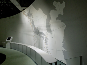
[Seismic Diorama: Breakdown Phenomenon Underground by Hypocenter Distribution]An earthquake is the result of a collapse of rocks underground. When you look at the "Seismic Diorama" which shows the distribution of the hypocenter around Japan, you can notice deeper hypocenters are zonally distributed in the continent side than pacific side. You might already know that the Earth's surface is separated into the rock plates known as "tectonic plates". The collapse tends to occur by friction derived from plate movement. Japan is a typical field where ocean plates are sinking under continental plates (subduction).
Why do plates which consist of solid rocks move? Because the rocks which stay under the plate (100 km depth) have relatively soft fluidity. It does not mean that the rocks are melted and sticky. Rock under the circumstances of high temperature and high pressure flow over a very long time. It is like the hard plate on top of the flow substance. The hypocenter distribution tells us the place where rock break underground.
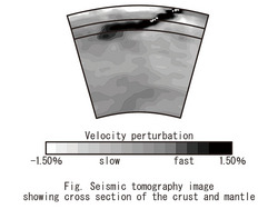
[Seismic Tomography]
We can investigate the deep underground with earthquakes. When we examine the inside of the human body, we check by X-ray or ultrasonic waves passing through the inside of the body and making a sectional view (CT= Computed Tomography) by computer processing. Likewise, in the case of the earth interior, we check the velocity of seismic waves and make a sectional view by computer. This is the "Seismic tomography". In Japan, many seismometers are installed and the underground structure is investigated thoroughly. We can understand the state of the plates which are sunk down and accumulated in the underground.
[Seismic Symphony: Putting into sound the Scale, Depth, Frequency, and Scale of Earthquakes.]This exhibit shows melodies that were created with the sounds, tones and intervals of which are respectively defined by the magnitude and depth of the earthquakes. When you hear the amazing sound with open ears, you might discover how very often earthquakes occur near Japan and also realize how the aftershock after large earthquake ends. The seismic data for this exhibit has been detected by the National Research Institute for Earth Science and Disaster Prevention, which has set seismographs at 800 places, 100m deep from the ground, and also runs the "High sensitive seismograph network (Hi-net)". This seismograph network plays an important role to elucidate the earthquake, aiming to estimate the underground structure around the Japanese archipelago.
Cooperation: Japan Agency for Marine-Earth Science and TechnologyNational Research Institute for Earth Science and Disaster PreventionArticle by Shoji Nishimoto, curator