Nagoya City Science Museum
TOP > Exhibition Guide > Keyword Search > Starting with "G" > Global Warming > World’s Rockets and Earth Observation Satellites

World’s Rockets and Earth Observation Satellites
Purpose of Exhibition
This exhibition is a combination of four categories, which are as follows:(1) wall surface graphic,(2) satellite station, (3)"Ibuki (GOSAT)" 1ï¼5 flight model which is hanging from the ceiling,(4) "global warming seen from the view of Ibuki".
Because the explanation focuses on "Ibuki (GOSAT)", the Japanese greenhouse gas observation experiment satellite, you can see the manufacturing process on the graphic wall, the structure of the satellite in the 1ï¼5 model and the example of sensing observation in the "global warming seen from the view of Ibuki" exhibit.
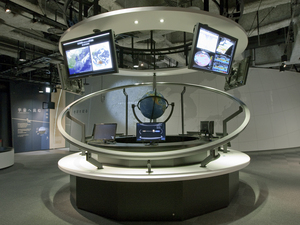
In the satellite station, the model of the earth observation satellite is on the table. You can take a seat and search the different models of earth observation satellites by using the information terminal.
Additional Knowledge
[Observation from the Earth Observation Satellite]
We can observe the changes and the state of the entire earth by observing from space. The satellite investigates the effects of global warming by observing greenhouse gases such as carbon dioxide. The changes in the ozone layer above the North Pole and the South Pole is also observed. We can see the mass generation of plankton and the contaminated sea through ocean observation, and also aim to prevent the extent of damage by investigating the decrease of forests and how natural disasters occur as well as the usual meteorological observation. It is also useful for the fishery industry and the discovery of underground resources.
[Remote Sensing]
Remote sensing is observation done far from the target objects and captures what is there. The state of the surface of the ground and atmosphere are observed from space by the earth observation satellite, which is far from the earth. Although it does not pick the substance out directly from there, it photographs visible spectrums and electromagnetic radiation our eyes can feel, and infrared rays enable us to investigate the heat on the surface of the ground and observe clouds in the air (water vapor). There is a method of observing the reflection of micro waves (radio waves) which are launched from the artificial satellites. It is because micro waves can go through the clouds, which allows us to observe the surface of the ground without the interference of clouds. It is possible to research the change of orbit of the artificial satellite and calculate the change of gravity on the earth, and according to the result, estimate the substances under the ground.
You can compare the difference between the infrared rays when they go through "Carbon dioxide" and "Nitrogen gas" by the infrared ray camera in "global warming seen from the view of Ibuki". It is possible to confirm artificially the observation that the earth observatory satellite does.
[The Orbit of Satellites (Low Altitude)]
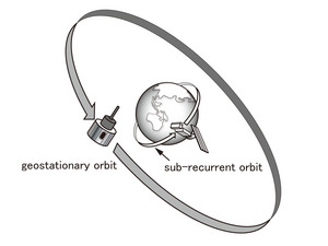
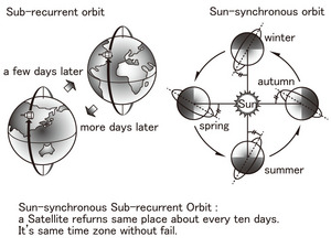
The line of rotation that the artificial satellite goes around the earth is called "orbit". When the artificial satellite is launched toward an area with relatively low altitude (a few hundreds of kilometers), it takes an hour or two to rotate around the earth. At this time, we can observe the earth by adjusting to the rotation of north-south direction due to the launch of the artificial satellite, and make it go through both the North and South Pole. During the rotation of the artificial satellite, the earth itself rotates toward the east direction. When the artificial satellite (which has started to observe at one point) rotates around the earth, the satellite reaches slightly upper west than its intended way ahead due to the earth's rotation. If it is to continue to do observation like this, the observation points would also move automatically toward the east-west direction, and it can observe the whole area of the earth while the artificial satellite rotates around the earth. We call the orbit like this "Sun-Synchronous Sub-Recurrent". We can recognize objects several meters above the ground by using high-resolution observational equipment, since the objects are located at a low altitude from earth. For example, we can observe the whole of the Chubu area at a time by using the equipment for wide range. The greenhouse gas observatory satellite "Ibuki (GOAST)" rotates around the polar orbit at an altitude of about 700 kilometers and observes the changes in the air across the whole earth.
[The Orbit of the Satellite (Geostationary Satellite)]
The period of revolution takes just 24 hours about 36000 kilometers above the equator. At this time, if the artificial satellite was rotating in the same direction as the earth, the rotation period of the earth and the artificial satellite would become the same. As a result, the artificial satellite always stays above the sky in the same position as the earth. This orbit is called the geostationary orbit and the satellite is called the geostationary satellite. From the satellite, we can observe the same side of the earth. It means that we can observe half of the earth at any one time. It is used for the geostationary meteorological satellite, which photographs the clouds.
Although it is not the earth observatory satellite, there is a communications satellite used for the satellite broadcast that is launched toward the geostationary orbit. Since the direction of the geostationary satellite is fixed from the ground, once the parabola antenna for domestic use is attached in the same direction, we do not need to change the direction.
The terrestrial globe in the satellite station and the circumference of the artificial satellite orbit are the same reduced scale as the real figure of the earth and the satellite orbit. You can intuitively compare the types and altitudes of the orbit of the artificial satellites rotating around the earth.
[The Name of Ibuki (GOASAT)]
"Ibuki" was chosen and named by the public before it was launched by JAXA. It is something of an affectionate nickname for it. On the other hand, the National Institute for Environmental Studies which conducts research for the observation of greenhouse gases gave it the name GOSAT (Green house gases Observing Satellite). In this exhibition, we use both names.
Cooperation:
Japan Aerospace Exploration AgencyArticle by Masao Suzuki, Curator