Nagoya City Science Museum
TOP > Exhibition Guide > Keyword Search > Starting with "M" > material > Climate and Life Style

Climate and Life Style

Purpose of Exhibition
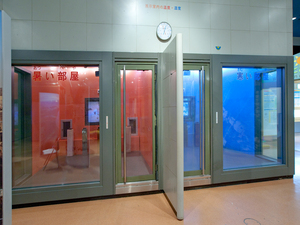
There are two rooms in the exhibition. At a temperature of 40 degrees (hot room) and at near the freezing point of water (cold room), you can have a little bit of a simulated experience of dry regions and far north regions by viewing a video, touching cloth or metal to think about different climates and different life styles. For example, the video shows you how they get drinking water, what sorts of clothes they wear and so on as seen in TV programs about world tours.
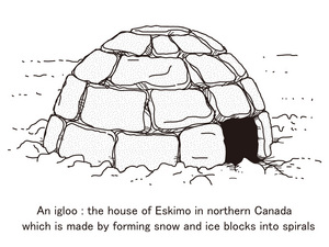
This exhibits also show you the relationship between the climate and the house located in a selected regions. People have comfortably lived in those houses built with the native soil or hay or even with ice in a certain region.
You can make comparisons among these displays on multiple matters including native products, dwelling characteristics and clothes.
Additional Knowledge
Mankind (we) neither has sharp fangs nor is it a thick fur-wearing creature. However, mankind, such vulnerable-looking "hairless ape", has established its habitats around the globe by making the most of its enormous brain power.
Mankind has successfully worked out know-how to protect itself from cold and rains in the natural environment full of problems related to climates, terrains, soils, water, etc., while it explored the natural environment to discover and make use of the necessities of life including foods, clothes and housing materials. Numerous industries including agriculture and manufacturing industry have advanced through mankind's efforts to keep its life in harmony with the natural environment.
Those of us who live in the urban areas are occasionally under the illusion of living with little or no relationship with nature, but in reality live in a vast natural environment called "Earth".
Vegetation distribution accurately reflects the climate. The vegetation-vegetation zone relationship is basically determined by the annual range of temperature, annual rainfall, nature of soil, insolation duration, etc. Vegetation distribution came to the attention of a German meteorologist named “Vladimir Koeppen” (1846 ‐ 1940), who created the Koeppen climate classification map.Koeppen first classified the world’s climates into whether they allowed vegetation to sprout out and grow or not and then depending on the monthly average temperature. He used three temperatures of 18 degrees, 10 degrees and -3 degrees as guides. The temperature of 18 degrees is believed to be most appropriate for human activities. 10 degrees is thought to be the borderline temperature of whether vegetation grows or not. 0 degrees is understood to be the temperature at which water is frozen. ‐3 degrees is considered to be the borderline temperature of whether snow cover continues or not. Understandably, the Koeppen climate classification map does not deal with the very substance of meteorological phenomena but it is often used on the ground that vegetation and human activities are closely interrelated.Incidentally, more "Taraxacum albidum" ("shirobana tanpopo" in Japanese), which is commonly found in Kyushu and Shikoku, are nowadays seen in Tokyo than ever before. That is presumably due to what is called "heat island phenomenon", which occurs in the urban area when the temperature is higher there than in the suburban area. No doubt that vegetation sensitively reacts to changes in temperature, rainfall and humidity.
Article by : Article by Chieko Ozaka, curator